
Science Kit
Scientific Instrument
- Power Supplies and Transformers
- Training Kits for Communication Lab
- Digital Electronic Experiments Computer Principles
- Study of Multivibrators
- Characteristics Operational Amplifiers
- Verification of Network Theorem
- Amplifiers Kits
- Demonstration Models
- Verification of Various Laws and Conservation of Signal
- Semi Conductor Devices
- Laser Experiment
- Characteristics Of Vaccum Tubes
- E M Apparatus Instrument
- Microprocessors
- OPTO Electronic Devices Equipments
- Digital Measuring Instruments
- Nuclear Physics
- Test and Measuring Instruments
Educational Rock and Minerals
Biology Equipment
- Prepared Slides Equipments
- Plant Equipment
- Magnifier Equipment
- Animal Equipments
- Biotechnology Equipments
- Cell Equipments
- Classification Equipments
- Dissection Equipments
- Electrophoresis Equipments
- Enzyme Equipments
- Genetics and Inheritance Equipments
- Health Equipments
- Human Biology Equipments
- Microbiology Equipment
- Molecular Model Equipment
Soil Testing
Rock Testing
Best Lab Equipment
Educational Lab Equipment
Analytical Lab Instrument
- Electrochemistry Instruments
- Flame Photometer
- Pharmacology Instruments
- Tablet Making Machine
- Apparatus For Isolated Uterus Intestine
- Water Still
- B.O.D. Incubator
- Egg Incubator
- Incubator Bacteriological
- Drying Oven Industrial
- Hot Air Universal Oven
- Shaker
- Incubators
- Hot Plate
- Clean Air Equipments
- Baths
- Autoclaves
- Surveying Instruments
- Pipette Washer (Automatic)
- Tissue Homogeniser
- Moisture Meter
- Mortuary Chamber
- Soxhlet Extraction Unit
- Kjeldahl Units (Without Glass Part)
- pH Meters
- Conductivity Meter
- Salinity Meter
- Dissolved Oxygen Meters
- Turbidity Meters
- Colony Counter
- Moisture Titrator
- Fluorometer
- Dissolution Test Apparatus
- Friability Test Apparatus
- Pyrogen Testing Instrument
- Tap or Bulk Density Apparatus
- Leak Test Apparatus
- Flocculator Jar Test Apparatus
- Microprocessor Flame Photometers
- Pharmacy Laboratory Equipments
- Respiration Pumps
- Brodie Operating Tables
- Embalming Tables
- Rat Operating Tables
- Small Animal Operating Tables
- Animals Holders
- Animals Head Holders
- Pneumograph Stethographs
- Spirometers
- Benedict Roth Recording Spirometers
- Digital Respinometers
- Organ Baths
- Isolated Organ Baths Digitals
- Four Unit Organ Baths
- Perfusions Lagendroff Assembly
- Dubois Raymond Keys
- Simple Keys
- Induction Coils
- Student Induction Coils
- Variable Interrupters
- Mosses Ergographs
- Compass Aesthesiometers
- Hand Grip Dynamometers
- Skin Fold Calipers
- Macerators
- Tablet Polishing Pans
- Tablet Making Machines (Electrically Operated)
- Tablets Making Machine Motorised
- Tablets Making Machine Hand Operated
- Apparatus Isolated Uterus Intestine
- Clean Air Benches
- Bio Safety Cabinet
- Laboratory Fume Hoods
- Fumigation
- Environmental Growth Chamber
- Ovens
- Water Distillation Plant
- Water Baths
- Hot Plates Warming Tables
- Dry Block Digester
- Shaking Machines And Stirrers
- COD Digester
- General Laboratory Equipment
- Spectrophotometer
- pharmaceutical-instruments/Pharmacology Equipments
Laboratory Apparatus
Laboratory Equipments Supplies
Engineering Lab Equipment
- Metallurgical Equipment
- Survey Instruments
- Incinerator
- Razor Sharpener
- Heat Transfer Lab Equipment
- Fluid Mechanics Lab Equipment
- Civil Engineering Lab Equipment
- Charts
- Bottle Top Dispenser
- Adsorption in Packed Beds
- Botany Charts
- Zoology Chart
- Chemistry Charts
- Physics Charts
- General Science Charts
- Genetics and Evolution Charts
- Human Physiology Charts
- Life Sketch of Scientists
- Food And Nutrition
- Health Care Series
- Prevent Diseases
- First Aid Charts
- Yogasana Charts
- Mathematics Primary Charts
- Charts on Geography
- Changing Face of the Earth
- Man and Environment
- Weather Maps of India
- Alphabet Charts
- Special Charts
- Moral Story Charts
- Specials Roll ups
- Struggle For Indian Freedom
- National Integration Charts
- Life Sketch of Great Men
- English Teaching Charts
- English Grammar Charts
- Military Science
- Army, Police and NCC Charts
- Maps Charts
- State Maps Political
- Civil and Draughtsman Equipment
- Nautical Compass
- Survey Equipment
- Soil Testing Equipments
- Measuring Instruments
- Tripods Stands
- Portholes
- Nautical Sextants
- Prism Sets
- CNC Trainer Machine
- Training Workshop Labs
- Mechanical Engineering Lab Equipment
- Air Conditioning and Refrigeration
- Automotive and Transportation
- Building Material Testing
Maths Lab Equipment
Porcelain Ware
Hospital Lab Equipments
Anatomical Models
- Dental Models
- Skeletons For Medical Students
- ENT Models
- Cancer Model
- Diabetes Model
- Implant Models
- Brain Models, Neuro Models
- Liver and Gastro Models
- Gynae Models, Female Health, Utreus Models
- Four Stage Liver Models
- Special Models
- Arthritis Models
- Heart and Artery Models
- Ortho Models
- Heart and Lungs Models
- Nurse Training Models
- Life Support Training Models
- Human Models
- Anatomical Models Equipments
Vocational Training Laboratory Equipment
- Woodworking Workshop Machines
- Wood Workshop Portable Tool
- Plant Engineering and Welding Equipment
- Welding Equipment and Workshop Lab Machine
- Standard Welding Equipment Set
- Electrical Work Bench
- Workshop Tools
- Plumbing Workshop Instrument
- Concrete Laboratory
- Soil Mechanics
- Hydraulics and Pneumatics
- Metal Manufacturing Training Machine
- Washing Machines
- Textile Technology
Lab Glassware
- Watch Glass Soda
- Voltameters
- Stirrers
- Test Tubes and Thermometer Pockets
- Staining Jars Glassware
- Specimen Tubes and Vials
- Spirit Burners
- Screwthreads, Discs and Joints
- Screw Caps, Stoppers and Stopcocks
- Distillation
- Extractors
- Coplins Jars
- Condenser
- Chromatography Columns
- Bends
- Beakers and Flasks
- Laboratory Adapter Oscilloscope Kit
Electronics Lab Equipments
- Variac Dimmerstats
- Signal Generators
- Fiber Optic Trainers
- Digital Storage Oscilloscopes
- Digital Electronics Trainer
- Communication Trainer
- Breadboard Trainers
- Analog Electronics Trainer
- Oscilloscopes
- Power Electronics Trainers
- Electronic Fundamentals
- Audio and Visual Technology
- Radio and Telephone Communications
- Electrical Technology
- Wiring, Distribution and Protection
- Electrical Motor Control
- Data Acquisition, Instrumentation and Process Control
- Lighting and Building Control Systems
Lab Plasticware
Chemistry Lab Equipment
Physics Lab Equipment
- Measurement
- Magnetisms
- Heat
- AP Physics
- Physics Lab Equipments
- Atomic Physics Equipment
- Density Equipment
- Electricity Equipment
- Electromagnetism Equipment
- Electrostatics Equipment
- Energy Transfer Equipment
- Force Motion & Dynamic Equipment
- Mechanics Lab Equipment
- Light & Optics Equipment
- Renewable Energy Equipment
- Sound and Waves
- Education Kit
Geography Lab Models
Mapping Equipment Manufacturer, Suppliers and Exporter in India
Jaincolab Manufacturers is leading Mapping Equipment Manufacturer,and supplier and Exporter in India, Algeria (Algiers), Angola (Luanda), Argentina (Buenos Aires), Armenia (Yerevan), Australia(Canberra), Austria (Vienna), Bahrain (Manama), Bangladesh (Dhaka), Bhutan (Thimphu), Bolivia (Sucre), Botswana (Gaborone), Brazil (Brasília), Brunei (Bandar Seri Begawan), Montenegro (Podgorica), Morocco (Rabat), Mozambique (Maputo), Myanmar (Naypyidaw), Namibia (Windhoek), Nepal (Kathmandu), New Zealand (Wellington), Nigeria (Abuja), Oman (Muscat), Palestine (Ramallah), Panama (Panama City), Papua New Guinea (Port Moresby), Paraguay (Asunción), Peru (Lima), Philippines (Manila)¸ Portugal (Lisbon), Qatar (Doha), Rwanda (Kigali), Saudi Arabia (Riyadh), Senegal (Dakar), Serbia (Belgrade), Sierra Leone (Freetown), Slovakia (Bratislava), South Africa (Cape Town) (Pretoria) (Bloemfontein), South Sudan (Juba), Spain (Madrid), Sri Lanka (Sri Jayawardenepura Kotte) (Colombo), Sudan (Khartoum), Syria (Damascus), Tanzania (Dodoma), Thailand (Bangkok), Togo (Lomé), Tonga (Nuku'alofa), Trinidad and Tobago (Port of Spain), Tunisia (Tunis), Turkey (Ankara), Turkmenistan (Ashgabat), Uganda (Kampala), United Arab Emirates (Abu Dhabi), United Kingdom (London), United States (Washington, D.C.)
JaincoLab Mapping Equipment supports map reading, orienteering and spatial geography with orienteering, plotting and pocket compasses, an inflatable geopolitical globe, a geophysical world map and a topographic modelling activity kit. Plotting compasses with one or two glass faces suit bearing work on paper charts, the 45mm pocket compasses and the orienteering compass with its declination scale suit field trips, and the contour-building kit lets students model landforms by hand.
Last updated: October 2026.
What is Mapping Equipment?
Mapping equipment is the set of instruments and classroom models used to teach map reading, orienteering and spatial geography — magnetic compasses for direction-finding, plotting compasses for bearing work on paper charts, inflatable and raised-relief globes, and topographic activity models that let students build and read contour landforms by hand. It is used in geography and earth-science practicals alongside the wider Geography Lab Models range covering astronomy, geology, weather and environment study.
Selected Mapping Equipment — Model Numbers and Specifications
| Product | Product Code | Published Specification |
|---|---|---|
| Orienteering Compass | JA-ME-7474 | Declination metric scale within the base plate, supplied with a lanyard |
| Plotting Compass (Two Glass Face) | JA-ME-7478 | Glass-faced on both sides, mounted in a 20mm-diameter aluminium ring |
| Pocket Compass 45mm | JA-ME-7480 | 45mm-diameter dial marked in degrees with N & S indications |
| Pocket Compass with Cover | JA-ME-7481 | 45mm-diameter compass graduated in degrees with compass points marked |
| Topographic Modeling and Mapping Activity Model | JA-ME-7484 | Contour-building activity kit for learning basic mapping technique |
Other listed items in this range include the Plotting Compass (One Glass Face) (JA-ME-7477), Inflatable Globe Geopolitical (JA-ME-7483) and Geo Physical World Map (JA-ME-7485); full dimensional specifications for these are available on request as part of a quotation.
Applications
| Setting | Typical Use |
|---|---|
| School / College Geography Lab | Direction-finding and bearing-plotting practicals using compasses |
| Outdoor Education / Field Trips | Orienteering practice with pocket and plotting compasses |
| Earth Science Classroom | Contour and relief-model building using topographic activity kits and globes |
Frequently Asked Questions
Q: How does Mapping Equipment differ from the other Geography Lab Models ranges?
A: Mapping Equipment covers compasses, globes and topographic models used for direction-finding and map reading. It is distinct from Astronomy Equipment (solar-system and space-science models), Geology Equipment (rock, mineral and earth-history collections) and Weather Equipment (meteorology instruments) within the same parent category.
Q: What is the difference between the one-glass-face and two-glass-face plotting compasses?
A: The Plotting Compass (Two Glass Face) (JA-ME-7478) is glass-faced on both sides and mounted in a 20mm-diameter aluminium ring, while the Plotting Compass (One Glass Face) (JA-ME-7477) has glass on one face. Both are used for bearing work on paper charts.
Request a Quote
To receive a quotation for the Orienteering Compass (JA-ME-7474), the Topographic Modeling and Mapping Activity Model (JA-ME-7484) or other mapping items, drop us a line with quantities and the delivery destination.
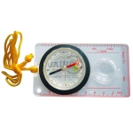
Orienteering Compass
Product Code : JA-ME-7474
Orienteering Compass (SKU JA-ME-7474): baseplate compass with liquid-filled capsule graduated 0-360 degrees, metric and declination scales, 25 mm magnifier, 108 x 60 mm, with lanyard.
Note: Baseplate orienteering compass, 108 x 60 mm, with liquid-filled capsule, declination scale, magnifier and lanyard.
View Details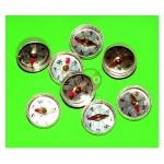
Plotting Compass (One Glass Face)
Product Code : JA-ME-7477
Plotting Compass, One Glass Face (SKU JA-ME-7477): 16 mm compass in an aluminium case with glass on one side and a dial marked with cardinal and ordinal points, for plotting magnetic field lines.
Note: 16 mm plotting compass in an aluminium case with a single glass face, for magnetic field plotting.
View Details
Plotting Compass (Two glass face)
Product Code : JA-ME-7478
Plotting Compass, Two Glass Face (SKU JA-ME-7478): glass faced on both sides, mounted in a 20 mm aluminium ring, supplied with a durable plastic storage case.
Note: Plotting compass glazed on both sides in a 20 mm aluminium ring, with plastic storage case.
View Details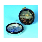
Pocket Compass 45mm
Product Code : JA-ME-7480
Pocket Compass 45mm (SKU JA-ME-7480): small compass in an aluminium case, 45 mm diameter, marked in degrees with N and S indications, for school geography and magnetism.
Note: 45 mm pocket compass in an aluminium case, marked in degrees with N and S indicated.
View Details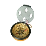
Pocket Compass with cover 45mm dia
Product Code : JA-ME-7481
Pocket Compass with cover 45mm dia (SKU JA-ME-7481): 45 mm compass graduated in degrees with compass points marked, hinged cover and needle-locking mechanism for transport.
Note: 45 mm pocket compass with hinged cover and needle lock, graduated in degrees.
View Details
Inflatable Globe Geopolitical
Product Code : JA-ME-7483
Inflatable Globe Geopolitical (SKU JA-ME-7483): inflatable world globe, 600 mm (as listed), showing countries, capitals, important cities, time zones and geographic features. Supplied by JaincoLab.
Note: Inflatable geopolitical world globe, 600 mm as listed, for classroom geography.
View Details
Topographic Modeling and Mapping Activity Model
Product Code : JA-ME-7484
Topographic Modeling and Mapping Activity Model (SKU JA-ME-7484): contour-model building activity covering map reading, scale, latitude, longitude, symbols and direction, with illustrated teacher's and student's guide. Supplied by JaincoLab.
Note: Contour-model mapping activity with illustrated teacher's and student's guide.
View Details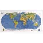
Geo Physical World Map
Product Code : JA-ME-7485
Geo Physical World Map (SKU JA-ME-7485): 3-D raised relief world map highlighting physical features and showing countries, cities and oceans. Size and material confirmed on the quotation. Supplied by JaincoLab.
Note: 3-D raised relief world map showing physical features, countries, cities and oceans.
View Details